In the first post of this series, we discussed how to get access to the geocaching website and use your smart phone for local geocaching on the fly.? Basically, you can get into geocaching around your local area for free.? However, if you head into the wild country, you?ll need a dedicated GPS device.? That?s the subject of today?s post.
Understanding a little bit about the GPS system itself will help you get the most out of your receiver.

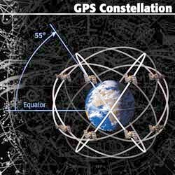
A depiction of the GPS constellation and its six planes. They run between zero and 55 degrees north and south latitude. If you are in the northern hemisphere, you get the best satellite signal by orienting your device south.
GPS is an American system that has been around since the late 1980?s. It consists of 24 satellites (called a constellation) in Medium Earth Orbit between 10,000 and 11,000 miles up.? In contrast, the International Space Station is only about 230 miles up.? The GPS satellites (and most other communications birds) are that high because 1) they get a direct line of sight (LOS) with a bigger portion of the earth?s surface and 2) gravity doesn?t suck them down to burn up in the atmosphere, making them steady and predictable.? Most of the satellites are in an equatorial orbit between 55 degrees north latitude and 55 degrees south latitude.? Except for the polar regions, coverage is worldwide but is always subject to the whims and restrictions of the local natural environment.
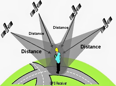
Your position is determined with GPS by a process called triangulation.? GPS satellites are active systems.? They are constantly broadcasting their position, time and identification. The GPS receiver, on the other hand, is a passive system.? All it does is listen for those satellite signals.? When it picks up a signal, it basically draws a line from it to the satellite.? That?s called a vector.? It takes at least three vectors with three different satellites to establish a position on the ground.? Your position is where the three vectors meet.? A fourth one is needed for altitude. Once that initial position is determined, the process becomes an endless loop of time hacks, vectors and converting results to position, speed, direction, etc.? That?s what all GPS receivers do ? some better than others.? All GPS-enabled devices use this system and work this way.
The single most important factor in GPS reception is the aforementioned ?Line of Sight (LOS)?.? For the GPS receiver to pick up and maintain a signal, it must have an unobstructed? 11,000 mile path to the satellite.? The single biggest obstacle to this is the curvature of the earth, but that is pretty much taken care of with the satellites up so high.? Buildings, terrain, heavy overhead cover, atmospheric conditions and a host of other factors can influence GPS reception.? Likewise, hardware and software inside the device can materially affect the results.? As I said in the first post, there is definitely a quality spread among GPS devices, especially phones.? In fact, given all that can go wrong, it?s amazing that the system works as well as it does ? and it does work extremely well.? It has proven reliable and resilient beyond all original expectations and it keeps getting better.

A graphic showing triangulation. At any given time, any point on earth (except for the polar regions) can ?see? at least four satellites. This will give you a position with latitude, longitude and altitude.
When GPS first came on line in the late 1980?s, it was restricted to the military and other government functions, such as air traffic control.? Its first big test was Desert Storm and it passed with flying colors, enabling the famous Hail Mary end run that? caught the Iraqi Army flat footed.? Moving at night through the Empty Quarter of the Saudi desert would have been impossible without GPS.
During those early years, there were civilian GPS receivers but by design, they were not allowed to receive the unfiltered GPS signal.? They threw in a fudge factor that essentially made the system useless.? That changed on May 2, 2000, when the fully functional GPS system was opened up to everybody.? The first geocache was placed the next day as a test of the new system by a GPS enthusiast and here we are 12 years and 2 million geocaches later.

This shows the pattern of orbits by the U.S. GPS System. There are 24 satellites placed in six different orbital geometric planes ? four per orbit. Each satellite circles the earth twice a day and they all transmit their signals together, synchronized by on-board atomic clocks. The six colors in this picture represent the six orbits. The only regions not thoroughly covered are the polar ice caps.
The three major players in handheld GPS devices for geocaching are Delorme, Garmin and Magellan.? You really can?t go wrong with any of them.? From a GPS standpoint, they are all up to the task.? It becomes a matter of what features you want and how much you?re willing to pay.? Top end GPS devices go for 400-500 dollars.
Pretty much everybody is going to the touch screens, which are nice but don?t work with gloves on.? You definitely want a USB computer interface.? For power, I prefer standard AA batteries.? They?re cheap and you can carry spares with you. The rechargeable NiCad batteries are expensive and wear out plus they can catch fire if wet.
Whatever you buy, get a protective case and a Zagat screen protector.
Also be aware that if you start buying GPS devices, you?ll be buying new ones sooner or later. I?m on my third generation.? I buy my toys at The GPS Store.? They?ve got the best prices and excellent customer service, including ?no questions asked? returns within 30 days.
So now that you know a little about GPS, here?s a few tips to help you in the field.
Keep the device flat as much as possible.? The antennae are oriented to receive signals from satellites, so you want maximum surface facing the sky.? If you point it up in the air, most of the antennae surface is useless.
To steady up a reading, keep moving around.? GPS corrects itself by detecting changes in speed and direction ? even small ones.? If you stand still, the GPS device essentially takes a break.? Keep up some sort of motion, even if it?s just moving the device around a little bit.
If you use the device at one location, then travel over 100 miles before you turn it on again, use the reset function in the menu to tell the device where you are.? Unless you tell it otherwise, it assumes you?re still at the place where it got turned off.? If you are some distance away, it can take quite a while for the GPS fix to come up. Resetting the device can speed that up considerably.
GPS, on its best day, will get you within about 10 feet of the coordinates.? If it gets to zero, it won?t stay there long.? If you can get a steady single digit reading, you?ve arrived.
The one thing that no handheld GPS device has ? yet ? is unrestricted Internet access.? There are some that will utilize Wi-Fi and Bluetooth to send text messages and some other rudimentary functions, but they aren?t the ?smart? devices that we?ve become used to.? If you start geocaching with dedicated GPS devices, you enter a world of searches, downloads and pocket queries.? You?ll have to find the caches online, download them to the device and then log your finds later.? All this requires Internet access.? It also eliminates geocaching on the fly.
You?ll probably end up doing what we do.? Depending on the circumstances, we use both our Droids and our Garmins, sometimes both at once.? For local caching and targets of opportunity, we do a search on the Droid and go hunting, knowing that the GPS function isn?t quite as robust as the Garmin.? On the other hand, if we?re planning a day of geocaching, we?ll do a search, filter the results then load up the Garmin.? This is especially true if we?re on the road or in the boondocks and won?t be back soon.
There are a number of software packages that you can use to quickly do searches, filters and downloads on to a device.? We?ll cover some of those in the next post.
Cheers ? The Cachemanian Devils
Like this:
3 bloggers like this post.
sag awards 2012 nominees sag awards pro bowl 2012 roster yamaguchi road house occupy oakland occupy oakland
No comments:
Post a Comment
Note: Only a member of this blog may post a comment.